
ARCHAEOLOGICAL SITES
Ruins of Mahakanadarawa Gal Palama
මහකනදරා පුරාණ ගල් පාලම නටබුණ්
NORTH CENTRAL PROVINCE
ANURADHAPURA DISTRICT
8°24'19.4"N 80°32'22.4"E
Scroll
A stone bridge for people who walked everywhere, built when nobody expected to go far.
Stand inside it — 360°
THE PLACE
The most important feature of the ancient Sri Lankan economy was its village-level self-sufficiency. The basic needs of the people were satisfied within the village community. Travelling between villages usually took place on foot as people did not usually travel long distances. Therefore there was no need for big roads linking villages.
However, bigger and better roads were required to link the important administrative and commercial centres. During the first few centuries of the Anuradhapura era, the main administrative centres were Anuradhapura and Trincomalee. There was a main road linking these two cities. Furthermore, major roads connected Anuradhapura with the ports of Dambakola Patuna (Jambukolapattana) in the Jaffna Peninsula, Manthota, near present-day Mannar and Gokanna (Trincomalee). These three ports were the most important trade centres during the Rajarata era.
The Anuradhapura-Dambakola Patuna Road was via Rambeva, Omanthai, Pavattakulam and Vavunikulama. This road had several stone bridges, including those near Anuradhapura over the Malwatu Oya and another at Pavattakulam over the canal starting from the reservoir. Stone beams and slabs of these bridges still exist. The most famous sight is the remains of a bridge at Perryapulankulama in Anuradhapura, commonly known as Galpalama or stone bridge.
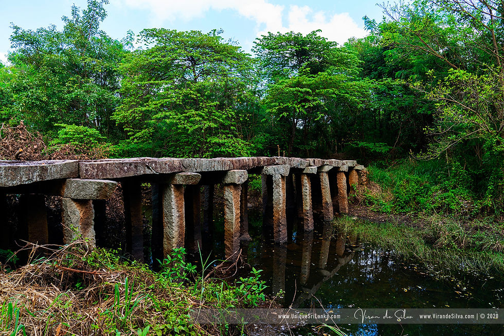
The best-preserved ancient stone bridge is the Mahakanadarawa stone bridge, built over the Kanadara River in the ancient road between Anuradhapura and Trincomalee (Gokanna). The present road connecting the two cities roughly coincides with the ancient road, which is a clear indication of the technological skills of the ancient Sri Lankans.
The existing structure at Mahakanadarawa is 80 feet in length and ten feet in width. Ten feet long, 14 stone beams of the size of 16 by 12 inches have been paved across it. The bridge is supported by 42 columns of 12 by 12 inches fixed on rocks on the bed of the river. The slabs of the bridge vary in sizes, the largest being eight feet long and 18 inches wide. The thickness of the slabs is six to eight.
(Heritage Lanka by Neil Kiriella 2017, P131)
THE PHOTOGRAPHS
THE PHOTOGRAPHER'S NOTES
Viran de Silva

nearDist
nearTitle
nearCat
nearDist
nearTitle
nearCat
nearDist
nearTitle
nearCat
nearDist
nearTitle
nearCat